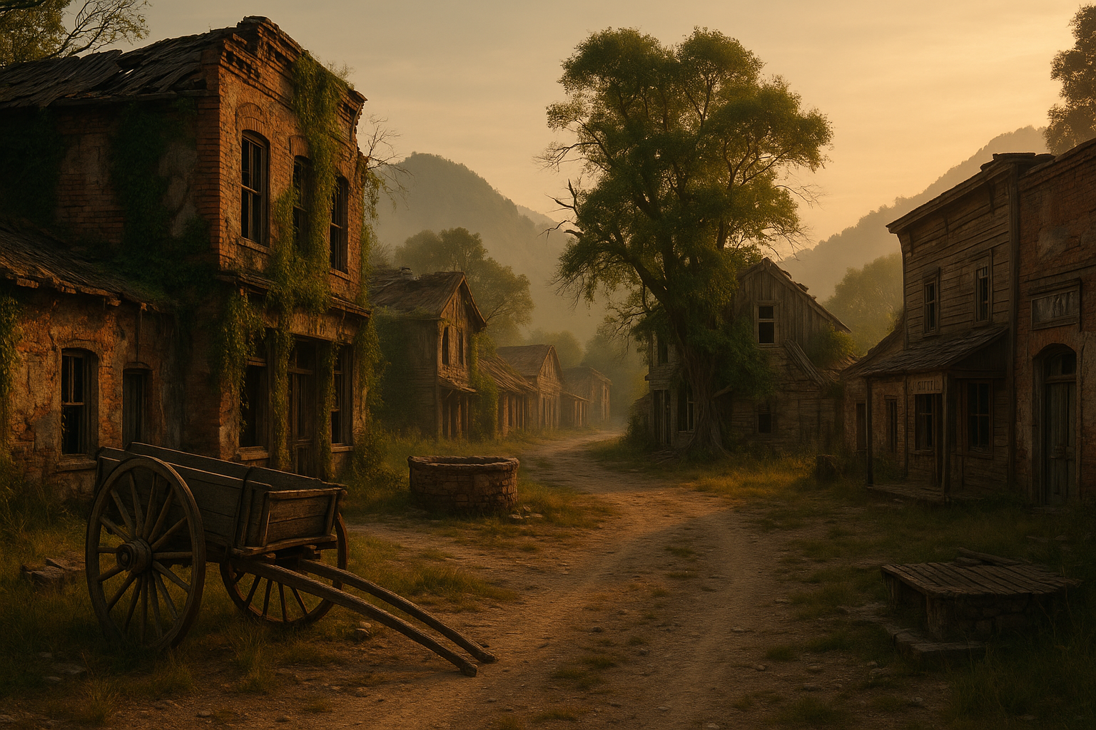
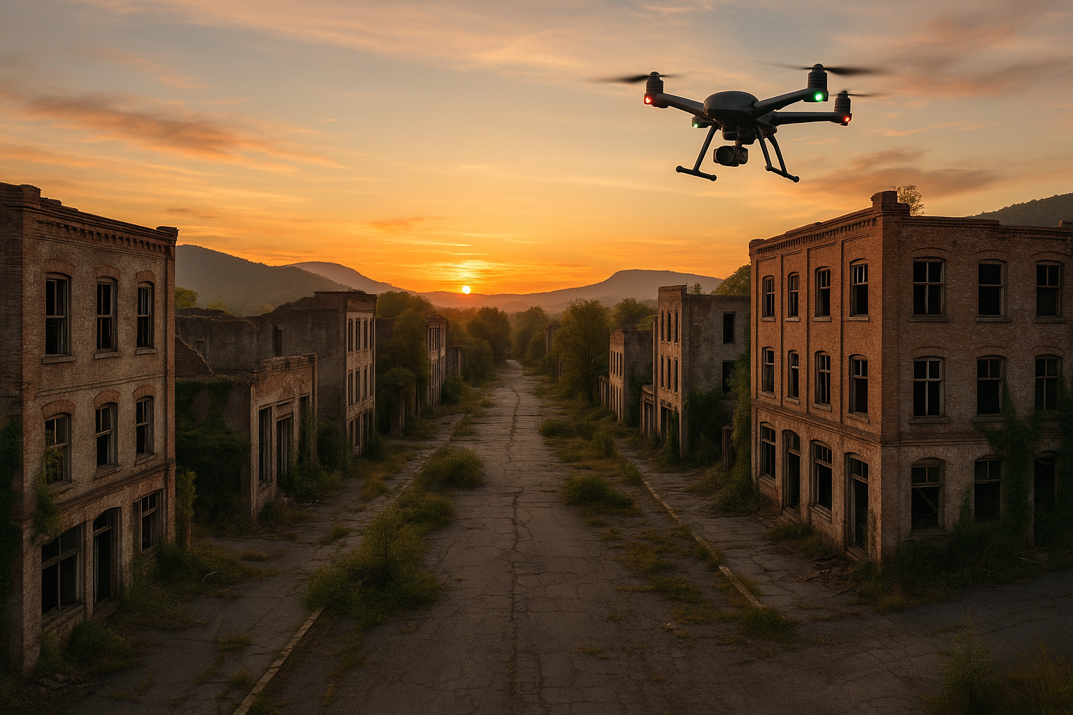
In a world that’s constantly evolving, where technology reshapes our daily lives, there’s a fascinating intersection of past and future that captivates the imagination. Picture this: abandoned ghost towns, once teeming with life, now stand as eerie reminders of forgotten eras. Yet, thanks to the marvels of modern technology, these desolate landscapes are being rediscovered in a way we never thought possible. Enter the realm of drone mapping—a revolutionary tool that unveils the haunting beauty of these ghost towns from breathtaking aerial perspectives. 🌍✨
Imagine soaring above the crumbling facades of once-thriving communities, capturing images that reveal the intricate tapestry of history etched into the earth. Drone mapping is not just a technological feat; it’s a narrative tool that stitches together stories of abandonment and resilience. The imagery captured by these high-flying devices offers more than just a bird’s-eye view; it provides a lens into the past, offering new insights into the lives that once animated these now-silent streets.
Our journey into the world of drone mapping and ghost towns will delve into the artistry and science behind this fascinating fusion. As drones dance above forgotten cities, they bring to light the beauty in decay, highlighting architectural marvels that have withstood the test of time. From the vibrant hues of rusting metals to the stark contrasts of nature reclaiming its space, each image tells a story of change and permanence.
But what exactly makes these ghost towns so intriguing? Perhaps it’s the mystery that surrounds their abandonment. Each town has its unique story—a sudden economic downfall, a natural disaster, or the slow march of industrialization rendering it obsolete. These factors weave together a narrative that invites exploration and reflection. Drone mapping allows us to document these tales with precision, capturing the very essence of what makes a ghost town both haunting and beautiful.
Throughout this article, we will explore several key themes: the technological advancements that have propelled drone mapping to the forefront of archaeological and historical research; the aesthetic and emotional impact of the images captured; and the stories of specific ghost towns that have been immortalized through this technology. By examining these aspects, we’ll uncover the secrets that lie hidden in the ruins, waiting to be discovered by those who dare to look beyond the surface.
One of the most compelling aspects of drone mapping is its ability to democratize exploration. Previously, documenting these remote locations required significant resources and manpower. Now, with a drone and a skilled operator, the mysteries of ghost towns are accessible to enthusiasts and researchers alike. This accessibility fuels a growing community of explorers who are passionate about preserving history and sharing it with the world. 🌐
We’ll also delve into the challenges faced by drone operators as they navigate these abandoned terrains. From unpredictable weather conditions to the technical difficulties of flying in remote areas, the path to uncovering these secrets is fraught with obstacles. Yet, it’s these very challenges that make the discoveries all the more rewarding.
Finally, we’ll take a closer look at some notable ghost towns that have been captured through drone mapping. Each town offers a unique glimpse into a bygone era, preserved through the lens of modern technology. Whether it’s the hauntingly beautiful Bodie in California or the isolated town of Kolmanskop in Namibia, these locations tell stories of ambition, hope, and eventual decline. Through drone mapping, these stories are no longer confined to history books; they come alive in vivid detail, sparking curiosity and wonder.
So, fasten your seatbelts as we embark on a journey through time and technology. Drone mapping is more than just a tool; it’s a gateway to understanding our past, a bridge that connects the forgotten with the present. As we uncover the secrets of ghost towns, we’ll not only appreciate the haunting beauty captured from above but also gain a deeper understanding of the forces that shaped these silent witnesses to history. 🚀🔍
Conclusion: Unveiling the Enigmatic Beauty of Ghost Towns
In our journey through the abandoned ghost towns scattered across the globe, we’ve uncovered stories frozen in time, captured through the innovative lens of drone mapping technology. This exploration not only sheds light on the historical and cultural significance of these neglected spaces but also highlights the stunning, yet eerie, beauty they possess.
Throughout the article, we have delved into the technological advancements that make drone mapping an indispensable tool for archaeologists, historians, and enthusiasts alike. These technologies allow us to document and preserve sites that were previously inaccessible, ensuring that the narratives of past communities are not lost to the annals of time.
The use of drones has revolutionized our understanding of these ghost towns, offering a bird’s-eye view that reveals hidden patterns and structures not visible from the ground. This perspective invites us to reflect on the transient nature of human settlements and the enduring legacy they leave behind.
Moreover, drone mapping’s ability to produce high-resolution, interactive maps fosters greater public engagement and awareness. These visual narratives not only captivate our imagination but also serve as educational tools that bring history to life for audiences worldwide. By bridging the gap between past and present, we are reminded of the stories that continue to shape our identities and communities.
As you contemplate the haunting beauty and historical intrigue of these ghost towns, consider how you might engage with this topic further. Whether through sharing this article with friends and family, leaving a comment below, or exploring similar abandoned sites in your vicinity, your involvement helps keep these stories alive. 🌍
In closing, the exploration of ghost towns through drone mapping is a testament to the power of technology in preserving our world’s heritage. It serves as an inspiration for future explorations and a reminder of the rich tapestry of human history waiting to be discovered. As we continue to uncover the secrets of the past, let us do so with curiosity, respect, and a commitment to preserving our shared legacy for generations to come. 🕰️
If this article has inspired you, share it with others who may find the beauty and mystery of ghost towns just as captivating. And don’t forget to leave your thoughts in the comments below – we’d love to hear your insights and any stories of your own explorations! 💬
Feel free to adjust the placeholder links and any specific content to better fit the details and research findings of your article.